Driving the Moors
Classic Car Driving Routes in the North York Moors
By Jon Cosson · Updated 18 October 2026
Six suggested touring routes for classic cars across the North York Moors, Sutton Bank, the B1257 'Yorkshire TT', Blakey Ridge, the A169 moor road, the coast road and the gentle Dalby forest amble. Each with distances, where to fill up, where to park and which pub to aim for.
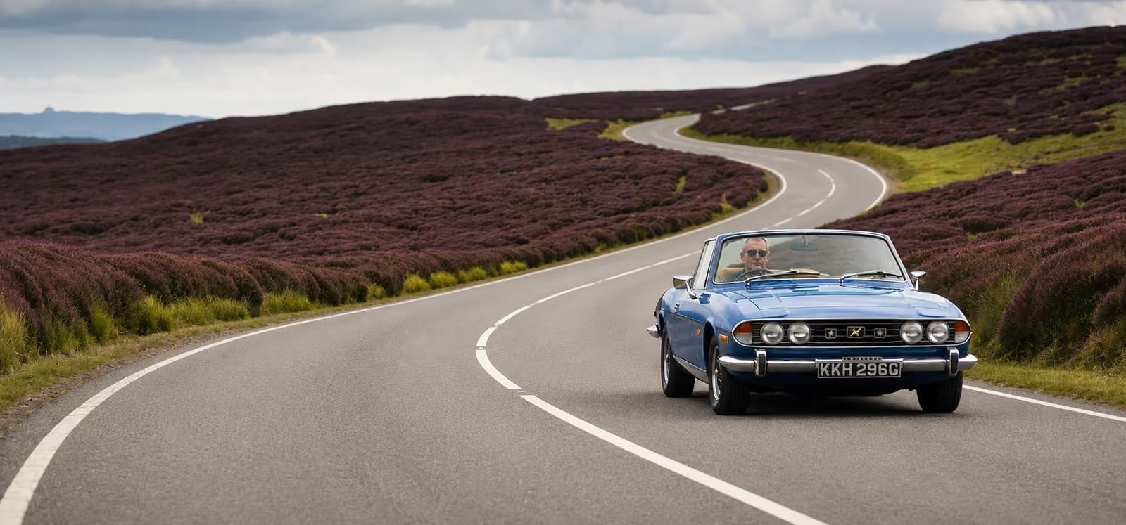
Moor-top touring: the roads here reward an unhurried pace.
This is classic-car country in more ways than one. It is Bangers & Cash territory, the Mathewsons auction house is just down the road in Thornton-le-Dale, and the moors are one of the great touring grounds in England for an older car: moor roads with sightlines measured in miles, dale lanes that never straighten, and a coast road with the North Sea on one side. These six routes can be driven individually in half a day each, or strung into a long weekend from a single base. Each one lists the practical details older cars actually need, where the last fuel is, where you can leave the car, and where to stop for lunch.
At a glance
- Headline route: the A169, Pickering to Whitby, about 22 miles of open moor and a sudden sea view.
- Steepest: Rosedale Chimney Bank, around one in eight average, one in three at its worst.
- Best light: late August into September, when the heather is out.
- Fuel: fill up in Pickering, Helmsley or Whitby before you climb.
- Conditions: gradients, closures and restrictions change, check before you set off.
1. Sutton Bank & the Hambleton escarpment
The finest view in England, plus the classic 1-in-4 climb
- Distance
- About 25 miles round trip from Helmsley
- Time to allow
- Half a day with stops
- Start
- Helmsley market place (A170 west)
- Fuel
- Fill up in Helmsley or Thirsk, there is no fuel on the bank itself
- Parking
- Sutton Bank National Park Centre (pay & display, large car park, café and toilets)
- Pub stop
- Helmsley's market-square inns, or the Hambleton villages below the escarpment
Route in order: Helmsley Market Place → Sutton Bank National Park Centre (Sutton Bank 1 in 4 with hairpin; caravans prohibited.) → A170 below Sutton Bank → Kilburn, White Horse turning → Coxwold → Helmsley Market Place
Mapped road distance: 24.4 miles. Optional extras are not included.
Google Maps may limit intermediate stops on some devices or choose different roads. The GPX contains the complete mapped line.
Route line drawn from OpenStreetMap road data to follow the roads described. Check closures, gradients and restrictions before you set off.
Routing: OSRM, map data © OpenStreetMap contributors. Locations checked October 2026. Fuel markers identify the towns named in the guide, not verified filling stations.
Driving note: Caravans and trailers are prohibited on Sutton Bank. The climb is hard on older cooling systems in summer traffic, watch the temperature gauge.
2. The B1257, the Yorkshire TT
Twenty of the best miles of tarmac in the North
- Distance
- About 50 miles, Helmsley to Stokesley and back over the tops via Osmotherley and Hawnby
- Time to allow
- Half a day
- Start
- Helmsley, heading north on the B1257
- Fuel
- Helmsley or Stokesley at either end; nothing in between
- Parking
- Newgate Bank forest car park and the Clay Bank top car park both make good photo stops
- Pub stop
- Chop Gate and the Bilsdale valley, or Great Broughton near the Stokesley end
Route in order: Helmsley Market Place → Newgate Bank car park (Steep gradient.) → Chop Gate → Clay Bank top car park (Steep gradient.) → Great Broughton → Stokesley → Osmotherley → Snilesworth moor road → Hawnby → Helmsley Market Place
Mapped road distance: 48.9 miles. Optional extras are not included.
Google Maps may limit intermediate stops on some devices or choose different roads. The GPX contains the complete mapped line.
Route line drawn from OpenStreetMap road data to follow the roads described. Check closures, gradients and restrictions before you set off.
Routing: OSRM, map data © OpenStreetMap contributors. Locations checked October 2026. Fuel markers identify the towns named in the guide, not verified filling stations.
Driving note: Very popular with motorcyclists at weekends, and there are steep gradients at both Newgate Bank and Clay Bank. Sheep roam freely; expect them on the road, not beside it.
3. Blakey Ridge & the dale heads
The roof of the National Park
- Distance
- About 45 to 50 miles from Kirkbymoorside via Hutton-le-Hole, Blakey Ridge, Castleton and Rosedale
- Time to allow
- Half a day, longer in heather season
- Start
- Kirkbymoorside or Hutton-le-Hole
- Fuel
- Kirkbymoorside or Castleton, there is no fuel anywhere on the ridge
- Parking
- Roadside pull-ins along the ridge, the Lion Inn car park for patrons, and the village car parks at Hutton-le-Hole and Rosedale Abbey
- Pub stop
- The Lion Inn at Blakey, one of England's highest inns
Route in order: Kirkbymoorside → Hutton-le-Hole → Lion Inn, Blakey Ridge (Parking for patrons.) → Castleton → Rosedale road turning → Rosedale Abbey → Blakey Ridge return, avoiding Chimney Bank → Hutton-le-Hole
Optional Chimney Bank: Rosedale Abbey → Rosedale Chimney Bank (1 in 3 at its worst; not for laden cars or marginal clutches.) → Hutton-le-Hole road above Chimney Bank
Mapped road distance: 47.6 miles. Optional extras are not included.
Google Maps may limit intermediate stops on some devices or choose different roads. The GPX contains the complete mapped line.
Route line drawn from OpenStreetMap road data to follow the roads described. Check closures, gradients and restrictions before you set off.
Routing: OSRM, map data © OpenStreetMap contributors. Locations checked October 2026. Fuel markers identify the towns named in the guide, not verified filling stations.
Driving note: High, exposed and prone to sudden mist even in summer; cattle grids, unfenced sheep and drifting snow in winter. Chimney Bank is genuinely severe, do not attempt it heavily laden or with a marginal clutch or cooling system, and check current conditions before you commit.
4. The A169 moor road to Whitby
Moor to sea, the classic top-down run
- Distance
- About 22 miles out, Pickering to Whitby, and about 30 miles back through the Esk Valley villages
- Time to allow
- A day if you stop at Whitby
- Start
- Pickering
- Fuel
- Pickering at the southern end, Whitby at the northern, nothing in between
- Parking
- Hole of Horcum car park at Saltergate for the view; multi-storey and park & ride options in Whitby, which fills early in summer
- Pub stop
- The Fox & Rabbit at Lockton on the way out; fish and chips on the harbour in Whitby
Route in order: Pickering → Fox & Rabbit, Lockton → Hole of Horcum car park, Saltergate → Whitby → Sleights → Blue Bank (Change down early.) → Grosmont → Egton Bridge → Goathland → A169 rejoining point → Pickering
Mapped road distance: 53.6 miles (outward: a169 22.5 miles; return: esk valley 31.1 miles). Optional extras are not included.
Google Maps may limit intermediate stops on some devices or choose different roads. The GPX contains the complete mapped line.
Route line drawn from OpenStreetMap road data to follow the roads described. Check closures, gradients and restrictions before you set off.
Routing: OSRM, map data © OpenStreetMap contributors. Locations checked October 2026. Fuel markers identify the towns named in the guide, not verified filling stations.
Driving note: Fast A-road with blind crests, and drivers slowing unpredictably for the Horcum viewpoint. The long descent into Whitby is hard on older brakes, and Blue Bank into Sleights is the one to respect: change down early and stay off the brakes, because drums fade.
5. The coast road and Robin Hood's Bay
Cliffs, bays and harbour towns
- Distance
- About 45 miles, Scarborough to Whitby to Pickering
- Time to allow
- A full day
- Start
- Scarborough, north on the A171
- Fuel
- Scarborough and Whitby; the A171 in between is bare
- Parking
- Park at the top of Robin Hood's Bay and walk down, the bank into the village is steep, narrow and no place for a classic
- Pub stop
- Robin Hood's Bay's old smugglers' inns, or Ravenscar for the view back along the bay
Route in order: Scarborough → Robin Hood’s Bay top car park (Do not drive down the bank.) → Whitby → Pickering
Optional Staithes detour: Whitby → Staithes upper village parking
Mapped road distance: 43.1 miles. Optional extras are not included.
Google Maps may limit intermediate stops on some devices or choose different roads. The GPX contains the complete mapped line.
Route line drawn from OpenStreetMap road data to follow the roads described. Check closures, gradients and restrictions before you set off.
Routing: OSRM, map data © OpenStreetMap contributors. Locations checked October 2026. Fuel markers identify the towns named in the guide, not verified filling stations.
Driving note: Sea fret can roll in without warning and salt air is no friend to old bodywork, a rinse afterwards is worth the trouble.
6. The Forest & Villages amble
The gentle one, for an unhurried open-top potter
- Distance
- About 25 miles round trip from Thornton-le-Dale
- Time to allow
- An afternoon or a summer evening
- Start
- Thornton-le-Dale
- Fuel
- Thornton-le-Dale or Pickering before you start
- Parking
- Staindale Lake and the Bridestones car parks inside the forest, and the village car parks at Thornton-le-Dale and Lockton
- Pub stop
- The Cayley Arms at Allerston: closed Tuesdays; from 5pm Monday to Saturday, with lunchtime opening on Sundays only
Route in order: Thornton-le-Dale → Low Dalby visitor centre → Staindale Lake car park → Bridestones car park → Lockton → Cayley Arms, Allerston → Thornton-le-Dale
Mapped road distance: 22.5 miles. Optional extras are not included.
Google Maps may limit intermediate stops on some devices or choose different roads. The GPX contains the complete mapped line.
Route line drawn from OpenStreetMap road data to follow the roads described. Check closures, gradients and restrictions before you set off.
Routing: OSRM, map data © OpenStreetMap contributors. Locations checked October 2026. Fuel markers identify the towns named in the guide, not verified filling stations.
Driving note: The forest drive has a 20mph limit and a Forestry England hourly parking charge; mind walkers, cyclists and families, and check the current rate on the Forestry England site before you go.
Making a weekend of it
Two days works beautifully: the B1257 and Sutton Bank on the first day from a western base around Helmsley, then Blakey Ridge, the A169 and the coast on the second. From the southern edge, Thornton-le-Dale, Allerston or Pickering, every route above starts within about forty minutes, and the Dalby Forest Drive makes a gentle evening amble when you have had enough of the tops. See where to stay for bases, and our itinerary if you want the non-driving highlights woven in.
Quiet lanes: Helmsley, Hutton-le-Hole and Goathland
For the gentlest, most timeless moors driving, forget the numbered routes and take the back roads between Helmsley and Hutton-le-Hole, or wander the lanes around Goathland, Heartbeat's Aidensfield, where it is all sheep, drystone walls and honey-stone villages, and nowhere to be in a hurry. These are shared, often single-track roads, so use the passing places and let faster locals through.
Driving an older car up here
- Fuel discipline. Treat the moor tops as a fuel desert, leave the last town with a comfortable margin, and remember many village pumps keep short hours.
- Cooling and brakes. Long climbs in summer traffic and long descents into Whitby and Robin Hood's Bay are where older cars struggle. Low gears down, gauge watched up.
- Sheep and cattle grids. Stock roam free on the unfenced moor roads, and lambs behave unpredictably in spring.
- Weather. Mist can drop over Blakey Ridge in minutes; ice lingers on the high roads long after the valleys have cleared.
- Signal. Mobile coverage is patchy above the 300-metre contour, so screenshot your route, take a paper map and note your recovery details before you set off.
- Parking. Mostly pay and display, and the big village car parks at Thornton-le-Dale, Hutton-le-Hole and Goathland fill by mid-morning at weekends. An old car in a tight coastal village is a liability: park high and walk down, particularly at Robin Hood's Bay and Staithes.
- Timing. These roads clog on warm weekends. Early mornings and weekdays are blissful; midday in August is a queue.
If the weather turns, the forest drive and trails at Dalby Forest make a sheltered alternative to the high moor.
Before you set off: the practical guides
Three things settle most touring questions, is the car legal, will it get home, and where should it go? We cover each in detail: classic car MOT and road tax exemption, the classic car breakdown kit, and classic car touring in the moors.
Where to point the car afterwards
You are in the heart of Bangers & Cash territory, so it is worth timing a tour with a Mathewsons viewing week in Thornton-le-Dale, see where to stay for the auctions. Our touring journal contains classic-car touring posts, and what's on lists the shows and rallies worth planning around.
More for classic-car enthusiasts
This guide covers routes for classic-car touring across the North York Moors. If you are an owner too, we also run a family of marque archives:
- MG T-Series archive
- AC Aceca archive
- Triumph Stag archive
- Jaguar Mk2 archive
- Alfa Romeo Giulia Spider archive
Driving routes FAQs
- What is the best classic car driving route in the North York Moors?
- The B1257 from Helmsley to Stokesley, the 'Yorkshire TT', is the classic choice for its flow and views, with Blakey Ridge the best for open moorland and the A169 the best moor-to-sea run.
- Where can I get fuel on the North York Moors?
- There is no fuel on the moor tops. Fill up in Pickering, Helmsley, Kirkbymoorside, Thornton-le-Dale, Stokesley, Castleton, Whitby or Scarborough before you head onto the high roads.
- How steep are Sutton Bank and Rosedale Chimney?
- Sutton Bank rises around 160 m in under a mile at roughly one in four, with a hairpin bend. Rosedale Chimney Bank averages around one in eight (13%) and reaches one in three (33%) at its steepest. Both are demanding on older cars, and caravans and larger vehicles are banned from Sutton Bank.
- When is the best time to drive the moors in a classic?
- Late August into early September for the heather, or midweek in May and June for empty roads. Avoid summer weekends when the coast roads and Whitby are busiest.
- What should I carry for a classic car trip on the moors?
- Screenshot your route before you leave, because mobile coverage is patchy above the 300-metre contour. Carry water, a basic breakdown kit and the number of a classic-friendly recovery service.
- Are there classic car events in the area?
- Yes, the moors have a full calendar of shows, rallies and Mathewsons viewing weeks. See our what's on page for the current year's dates.
The village and classic-car sister sites linked here are also written by the author of this guide.
A base for a two-day tour
A southern-moors village base puts the A169, Dalby and the Mathewsons saleroom within easy reach. Practical for an overnight stop on a two-day tour.
Browse places to stay