Plan Your Visit
Accessible North York Moors: where can you actually go?
If you use a wheelchair, a mobility scooter or a pushchair, or you simply cannot walk far, most guides to the North York Moors are of little use to you. The National Park Authority publishes the raw material across its Access for all pages, and nobody joins it up or explains it in plain words. This page does that, and adds what we know first-hand.
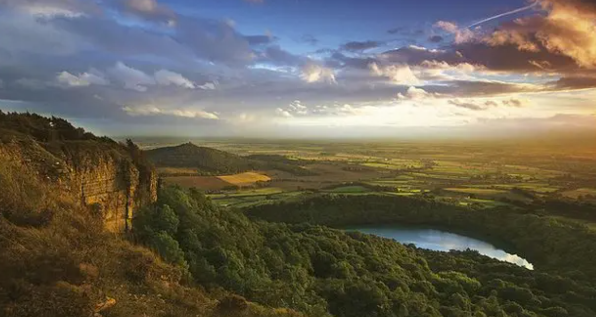
Sutton Bank, where an accessible path, a viewing platform and a National Park Centre mean nobody has to miss the finest view in England.
Accessible North York Moors at a glance
- The grading scheme
- Miles without Stiles, three tiers: For all, For many and For some
- Graded walks we can name
- Four, from the National Park's own scheme
- Viewpoints with little or no walking
- Ten, from the National Park's accessible viewpoints list, grid references included
- Tramper hire
- Six hubs across the park; we can confirm Dalby Forest and Sutton Bank
- Accessible toilets named here
- Dalby Forest visitor centre, Sutton Bank, Scaling Dam, Staindale Lake, Roseberry Topping car park
- Carer ticket, steam railway
- £15.00, the fare we paid on 18 September 2026, not a published price
How the National Park grades an accessible route
The National Park Authority grades its accessible routes under a scheme called Miles without Stiles, in three tiers. The tier names mean nothing on their own, which is the whole problem, so here is what each one actually tells you, according to the National Park Authority's own grading.
- For all
- Suitable for everyone, including pushchairs and people operating their own wheelchairs. Gradients no steeper than 1:10. Smooth tarmac or compacted stone, maximum 10mm. Minimum path width one metre.
- For many
- For assisted wheelchair users and robust buggies. Gradients up to 1:10, or 1:8 on newly built paths. Rougher stone surfaces, up to 4cm.
- For some
- For confident wheelchair users and off-road mobility scooters. Gradients unrestricted, though slopes steeper than 1:8 have improved surfacing or handrails. May include low steps up to 10cm and stone up to 10cm.
Two things are worth saying in plain terms. First, the tier tells you about the surface and the gradient, not about the length or the remoteness of a route, so a graded path can still run for miles through open country. Second, For some is a real grading that assumes a confident user and decent equipment, not a gentle stroll. If the person pushing, or the chair, is going to be tested, that is the tier where it happens.
We are explaining their scheme and adding to it, not replacing it. The National Park adds and regrades routes, so its own Miles without Stiles page is the live list. Ours is the page that explains what the gradings mean and adds what we know first-hand.
The accessible walks we can name
Runswick Bay, graded For some. About 1.2 miles out and back, starting from the top car park at Runswick Bay, which is pay and display. It follows the Cleveland Way from near the Runswick Bay Hotel towards the cliff edge, on a smooth aggregate path that becomes grassy and sometimes rough along the cliffside, passing through two fields. It is reasonably level with a few slight rises, and there is a bench on the cliff path. The nearest accessible toilets are at the Staithes top car park. This description comes from the National Trails route notes rather than our own feet.
Sutton Bank and the White Horse, graded For many. This is also one of the National Park's accessible viewpoints, with an accessible path, a viewing platform and a wheelchair and pushchair route towards the Kilburn White Horse, and a National Park Centre with a café on site. The bank itself, the centre and the walk are covered in our Sutton Bank guide and our White Horse walk.
The Farndale daffodil path, graded For some. A largely surfaced path with gates rather than stiles and a few short gradients, which is where the wild daffodils draw the crowds in spring. The field-path return has occasional stiles and is not part of the accessible route. The full detail is in our Farndale daffodils walk.
Thornton-le-Dale to Ellerburn, graded For some: gentle gradients and no steps or stiles, though kissing gates make it unsuitable for mobility scooters and Trampers. That caveat is exactly the kind of detail that decides a day out, and it is why we say which of these routes we have judged ourselves. Details in our Thornton-le-Dale walk, and the village's own walks page describes a wheelchair-friendly village pond loop too.
Rosedale Bank Top and Ravenscar both have Miles without Stiles routes, according to the National Park's accessible viewpoints page. We do not have their gradings, distances or surfaces, and we have not yet checked them ourselves, so we will not describe them. We would rather leave a gap than send someone on a two-hour drive to a path they cannot use.
This is deliberately not a definitive list of every Miles without Stiles route in the park. The National Park adds and regrades them, and a stale list is worse than a link. Their own page is the complete and current one.
Viewpoints you can reach without walking far
This, we suspect, is the question people actually have: where can I take my mother, or my husband, and still see the view? The National Park's accessible viewpoints page answers it, and these are its ten, with their grid references, so you can find them on a paper map where phone signal will not help you.
| Viewpoint | Grid reference | What there is |
|---|---|---|
| Sutton Bank | SE516831 | Accessible path and viewing platform, with the wheelchair and pushchair route towards the Kilburn White Horse. National Park Centre with café on site. |
| Cowhouse Bank | SE613886 | Car park with viewpoint. Helmsley 3 miles. |
| Newgate Bank | SE564890 | Picnic area at the top of the bank with viewpoint access. Helmsley 5 miles. |
| Gillamoor, Surprise View | SE684902 | Viewpoint and bench beside the church. Hutton-le-Hole car park 2.5 miles. |
| Rosedale Bank Top | SE721947 | Viewpoint near the kiln ruins, with a Miles without Stiles route. Rosedale Abbey nearby; Hutton-le-Hole car park 3 miles. |
| Clay Bank | NZ572036 | Car park and picnic area. Chop Gate 3 miles. |
| Runswick Bay, Bank Top | NZ808161 | Cliff-top car park and the 1.3-mile accessible walk along the Cleveland Way. Staithes 3 miles. |
| Whitby | NZ905109 | Wheelchair-accessible trail from Abbey Fields, with ramp access to the holiday park's café and toilet. |
| Blue Bank car park | NZ867058 | Parking area off the A169. Whitby 4.3 miles. |
| Ravenscar | NZ980015 | Miles without Stiles route with cliff views, facilities on site. |
Trampers, adapted cycles and facilities
Tramper hire. Six Tramper hubs across the park offer all-terrain mobility scooters for hire, according to the National Park's accessible outdoor activities page. We can only confirm two of them: Dalby Forest, which has two Trampers and requires advance booking, and Sutton Bank, which has two Tramper routes. We have not identified the other four hubs and will not guess at them. Mobility scooters are also available at Dalby Forest. We state no hire prices or booking arrangements here, because they change and the National Park's page is the one that stays right.
Adapted cycles. The Dalby Forest Cycle Hub keeps adapted cycles for a range of abilities, alongside the ordinary hire fleet, which makes the forest's flat, wide forest roads a genuine option for families where a wheelchair or a bike is the only way round.
Accessible toilets. The National Park names them at the Dalby Forest visitor centre, the Sutton Bank National Park Centre, and the western end of Scaling Dam Reservoir. Our own walks research also records accessible toilets at Staindale Lake in Dalby Forest and at the Roseberry Topping car park. The Dalby Forest visitor centre has level access, an accessible toilet and a hearing loop.
Other places the National Park lists as accessible: Cod Beck Reservoir at Osmotherley, Scaling Dam Reservoir, Mulgrave Woods at Sandsend, Raincliffe Woods, the Cinder Track, and Friars Hill Riding Stables at Sinnington, which also appears in our guide to horse riding. We have no access detail for most of them beyond the listing, and we will not invent any. The National Park's own page carries what detail exists.
The steam railway carer ticket
This is the thing on the page that is ours alone, because we went and paid it. On 18 September 2026 we travelled on the North Yorkshire Moors Railway and our own tickets show a carer ticket at £15.00 alongside an adult return at £35.00. The carer fare is not published on the railway's website, and a carer can easily spend twenty minutes failing to find it. To be clear about what this figure is: it was the fare we paid on the day, not a current published price. For current fares, check the railway's own site at nymr.co.uk, and our railway guide for everything else a first visit needs.
What we do not know yet
A wrong access statement is worse than no access statement: it sends someone on a two-hour drive to a path they cannot use. So here, plainly, is what this page does not know. We have identified only two of the six Tramper hubs, and we will not guess the other four. We do not have a list of the Changing Places toilets in the park, only the knowledge that the National Park references them. We do not know the blue badge parking arrangements at National Park car parks, including whether charges are waived. We do not know whether Rosedale Bank Top and Ravenscar are graded For all, For many or For some. We do not know whether any accessible route here has a British Sign Language, audio, large print or easy read version. We have checked none of the accessible accommodation the National Park lists.
We are working on all of it, and the fastest way to make this page better is you. If you know one of the answers, or you find something on this page wrong on the ground, please tell us. First-hand corrections from people who actually use these paths are how this page earns its keep, and they are what no official page can copy.
Accessible North York Moors: FAQs
What does Miles without Stiles mean?
It is the North York Moors National Park Authority's grading scheme for its more accessible walking routes, in three tiers. For all means suitable for everyone, including pushchairs and people operating their own wheelchairs, with gradients no steeper than 1:10 and a smooth tarmac or compacted stone surface. For many means for assisted wheelchair users and robust buggies, with gradients up to 1:10, or 1:8 on newly built paths, and rougher stone surfaces up to 4cm. For some means for confident wheelchair users and off-road mobility scooters, with gradients unrestricted and possibly low steps up to 10cm. The full definitions are in our guide below and on the National Park's own Miles without Stiles page.
Are there wheelchair-accessible walks in the North York Moors?
Yes, though they are a small subset of the park's paths. Four graded Miles without Stiles routes can be named here: Runswick Bay (For some), Sutton Bank and the White Horse (For many), the Farndale daffodil path (For some) and Thornton-le-Dale to Ellerburn (For some), each described in this guide. The National Park also lists Miles without Stiles routes at Rosedale Bank Top and Ravenscar, which we have not yet checked ourselves. The National Park adds and regrades routes, so its own Miles without Stiles page is the live list.
Where can I hire a Tramper or an all-terrain mobility scooter?
The National Park lists six Tramper hubs across the park. We can confirm two of them: Dalby Forest, which has two Trampers and requires advance booking, and Sutton Bank, which has two Tramper routes. We have not identified the other four hubs, so check the National Park's accessible outdoor activities page for the current list rather than trusting us for the rest. Mobility scooters are also available at Dalby Forest, and adapted cycles for a range of abilities come from the Dalby Forest Cycle Hub.
Which viewpoints can I reach without walking far?
Ten of them, on the National Park's own accessible viewpoints list, are set out in the table in this guide with their grid references: Sutton Bank, Cowhouse Bank, Newgate Bank, Surprise View at Gillamoor, Rosedale Bank Top, Clay Bank, Runswick Bay Bank Top, a wheelchair-accessible trail at Whitby's Abbey Fields, Blue Bank car park and Ravenscar. Most involve a car park or a short, level path rather than a walk.
Are there accessible toilets in the North York Moors?
The National Park names accessible toilets at the Dalby Forest visitor centre, the Sutton Bank National Park Centre and the western end of Scaling Dam Reservoir. Our own walks research also records accessible toilets at Staindale Lake in Dalby Forest and at the Roseberry Topping car park. If you are walking the Runswick Bay route, the nearest accessible toilets are at the Staithes top car park. We have no reliable list of Changing Places toilets in the park, so we do not claim one.
Is there a carer ticket on the steam railway?
There was for us. When we travelled on the North Yorkshire Moors Railway on 18 September 2026, our tickets show a carer ticket at £15.00 alongside an adult return at £35.00. That figure comes from our own tickets rather than the railway's published prices, and we cannot say it is the current fare. The railway's own site and our North Yorkshire Moors Railway guide are where to check before you travel.
Planning the trip around access
The routes and viewpoints on this page are spread across the park, so it pays to pick a base that puts the easy ones in reach.
Browse places to stay