Villages & Places
Robin Hood's Bay
By Jon Cosson · Updated 19 October 2026
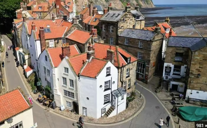
Bay Town falls off the edge of the moors in a tangle of red pantile roofs, cobbled alleys and passageways barely wide enough for a fish barrel. It is a coastal village, the end of the Coast to Coast, and a place where two practical things decide your day: where you park, and what the tide is doing.
Things to do in Robin Hood's Bay
- Walking the bank: the steep street and alleys down through Bay Town.
- The beach and rock pools: best at low tide, but the tide comes in quickly and can cut off the bays, so check it first.
- The Old Coastguard Station: at the foot of the village.
- Walks: the Cleveland Way and the beach to Boggle Hole.
- Pubs: food, drink and dogs.
Where it is, and getting there
Robin Hood's Bay, North Yorkshire, sits on the coast six miles south of Whitby, at the eastern edge of the North York Moors National Park. By car it is 15 minutes from Whitby on the A171 and B1447, about an hour from Pickering over the moor road through Goathland, and around 30 minutes north of Scarborough. Buses run along the coast road from both Whitby and Scarborough and stop at the top of the village, check the current timetable before relying on the last one back.
Two car-free approaches are better than the drive if you have the legs for them: the Cinder Track, the old Whitby to Scarborough railway line, which runs level all the way from Whitby and is fine on a hybrid bike (see our cycling guide), and the Cleveland Way cliff path, the National Trails 6.4-mile stage from Whitby Abbey.
See buses to and from Whitby for the X93 route and live timetable links.
Parking: the one thing to get right
Use Bank Top car park, YO22 4RL, or Station car park, YO22 4RE, both in the upper village, and walk down. The old village is a scheduled maze of cobbles and steps with no visitor parking whatsoever; the road down the bank is for residents, deliveries and the occasional very brave driver, and there is nowhere to turn at the bottom. Cars do get stuck and cars do get ticketed.
The top car park is large but fills by mid-morning on summer weekends and through the school holidays. Arrive before ten or after four for the best of it. There are toilets at the top and near the slipway, and a seasonal shuttle bus sometimes runs down the bank in high summer, ask in the village rather than counting on it.
Walking the bank
From the car park to the slipway is about half a mile down a gradient of roughly 1 in 3. It is ten minutes down and a good twenty back, and the return climb catches people out, particularly with small children, a pushchair or a dog that has already had its walk. Wear proper shoes: the cobbles are polished and slick in the wet.
The reward is the village itself. Openings between the cottages lead into alleys and passages (the “bolts”) that thread between houses and open onto tiny yards. This was one of the busiest smuggling coasts in England, and the village layout is the evidence. Take the Openings and Chapel Street rather than following everyone straight down the main run, the best of Bay Town is off to the sides.
Robin Hood's Bay beach
Check the Robin Hood's Bay webcam links for views across the beach and bay.
Before taking the beach towards Boggle Hole, see tide prediction services and coastal safety advice.
The slipway at the bottom of the village leads onto a rocky shore. Low tide exposes rock pools and fossils. The tide comes in quickly and can cut off the bays. Check tide times first and stay away from the foot of the cliffs.
At high water the sea reaches the sea wall and there is no beach at all. Two hours either side of low tide, a huge shelf of rocky scars is uncovered, flat ledges of shale and limestone, full of pools, and one of the best rock-pooling shores in Yorkshire. Check a tide table for Whitby or Robin Hood's Bay before you set off; it changes the day completely.
The same rocks make this prime fossil-hunting country. Ammonites and belemnites weather out of the Jurassic shales and are found loose on the foreshore, collect from the beach, never hammer the cliffs, and keep well clear of the cliff base, which is actively slipping.
Boggle Hole lies a mile south: a wooded cove with a National Trust connection, a youth hostel and cafe, named after the “boggles”, goblins, of local folklore. You can walk there along the beach at low tide, but do it on a falling tide only, or take the cliff path and come back along the shore.
The Old Coastguard Station stands at the foot of the village. This National Trust site has an exhibition room and a second-hand bookshop. Its café has closed.
Pubs, food and dogs
The Bay Hotel at the very bottom is where Coast to Coast walkers dip a boot in the sea and sign the book; the Dolphin and the Laurel Inn, a tiny former fisherman's bar, are the village institutions, and the Victoria Hotel at the top has the view down over the whole bay. Add tea rooms, a chip shop, an ice-cream shop and a good bakery on the way down.
It is a thoroughly dog-friendly village: most pubs welcome dogs, the beach is open to them outside the summer restriction on the main bathing stretch, and the cliff path and Cinder Track are on the doorstep. More ideas in our dog-friendly pubs guide and the wider food and drink section.
Walks from the village
The clifftop Cleveland Way National Trail passes through the village.
Boggle Hole circular (about 3 miles). South along the Cleveland Way to Boggle Hole and Stoupe Beck, back on field paths or, tide allowing, along the beach. Short, varied and the classic first walk here.
Ravenscar and the Cinder Track (about 8 miles). Cliff path south to Ravenscar, the “town that never was”, with alum works ruins and seals often hauled out below, returning level along the old railway. A proper day out.
Whitby along the coast (6.4 miles one way). North on the Cleveland Way to Whitby Abbey, with the bus or the Cinder Track for the return. See more routes across the park in our walks section.
Making a day, or a few days, of it
Bay Town pairs naturally with Whitby, Staithes and Runswick Bay along the Heritage Coast, and it is an easy add-on to a moors trip: the drive over from Goathland and the steam railway takes half an hour of good moorland road. Half a day covers the village; a full day covers the village, the scars at low tide and a cliff walk. See our suggested itinerary and where to stay for how to fit it in.
Robin Hood's Bay FAQs
- Where do you park in Robin Hood's Bay?
- At Bank Top car park, YO22 4RL, or Station car park, YO22 4RE, both in the upper village. The old village below is a steep, narrow maze of cobbled alleys with no visitor parking at all, and the bottom of the bank is for residents and deliveries only. Park at the top, walk down, and allow for the climb back up.
- How steep is the walk down into Robin Hood's Bay?
- The bank drops roughly 1 in 3 over about half a mile from the car park to the slipway. Going down takes ten minutes; coming back up takes twenty and a stop or two. It is hard going with a pushchair or limited mobility, there is a seasonal shuttle bus in summer, but check locally whether it is running before you rely on it.
- Do you need to check the tide at Robin Hood's Bay?
- Yes. The sea comes right up to the sea wall at the bottom of the village at high tide, and the rocky scars that make the beach so good for rock-pooling and fossils are only exposed either side of low water. Check a tide table for Whitby or Robin Hood's Bay before you go, and never walk the beach towards Boggle Hole on a rising tide.
- Is Robin Hood's Bay dog friendly?
- Very. Dogs are welcome on the beach outside the summer restriction that applies to the main bathing area, most of the pubs and several cafes take dogs, and the cliff path and Cinder Track both make good walking with dogs under control. Bring a towel, the scars are wet, muddy and irresistible.
- How far is Robin Hood's Bay from Whitby?
- About six miles south, roughly 15 minutes by car on the A171 and B1447, or an hour by bus. On foot it is 6.4 miles along the Cleveland Way cliff path, or a flatter ride or walk on the Cinder Track, the old railway line between the two.
- Why is it called Robin Hood's Bay?
- No one knows for certain. The name was recorded as "Robyn Oeds Bay" in a letter dated between 1324 and 1346, and the English Place-Name Society's view is that it probably came from the popular Robin Hood ballads. There is no evidence Robin Hood ever came here, though local legends tell of him keeping boats in the bay.
- Is there a beach at Robin Hood's Bay?
- Yes. The beach is reached by the slipway at the bottom of the village. Check the tide times before you go down, because the sea comes right up to the sea wall at high tide. See where to check Whitby tide times.
Nearby
Checked October 2026: National Trust Yorkshire Coast; Council Bank Top parking; Council Station parking. Name history: Robin Hood's Bay local history wiki; Countryfile.
Stay within reach of the coast
Bay Town's own cottages book up months ahead and parking is a genuine problem. Plenty of visitors base themselves inland on the southern edge of the park, around 50 minutes from the coast, and drive over for the day.
Browse places to stay