Walks
Roseberry Topping
With its half-cone summit and jagged cliff, Roseberry Topping is one of the most recognisable hills in the North York Moors. 'Yorkshire's Matterhorn,' standing over the north-western edge of the park near Great Ayton. It's not the highest hill, but few give more view for the effort. You can be up and down in under an hour, or make a proper circular day of it taking in Captain Cook's Monument.
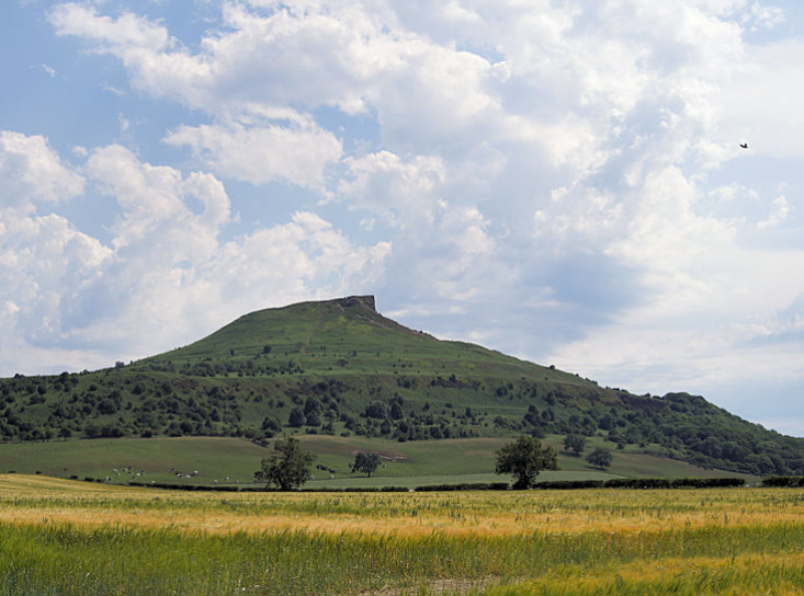
Roseberry Topping from the fields below, its familiar half-cone profile under a summer sky.
The walk at a glance
- Distance
- From about 1 mile there-and-back (direct climb) to a 5-mile circular, or around 6 miles taking in Captain Cook's Monument
- Ascent
- Around 200 m (676 ft) on a 2.2-mile loop from Newton-under-Roseberry, per the walking site yorkshiremoors.co.uk, which is not connected to this guide. Published figures for the longer circular taking in Captain Cook's Monument disagree, from about 364 m (1,200 ft) to about 515 m (1,700 ft)
- Time
- 45 minutes for the quick climb; 2 to 3 hours for a circular
- Difficulty
- Moderate, a short, steep climb with steps, strenuous in bursts; steep stone steps on the descent
- Start & parking
- North York Moors National Park pay-and-display car park; Newton-under-Roseberry, on the A173; Pay and display, charge applies including for National Trust members; grid ref NZ 570 128; nearest postcode TS9 6QR
- Map
- OS Explorer OL26 (North York Moors, Western area)
- Dogs
- Welcome, on a lead around livestock.
- Pushchairs
- Not suitable. The National Trust describes diverse terrain, uneven surfaces and some steep gradients
- Wheelchairs
- Not suitable. The National Trust describes paths as uneven, steep and muddy in places. There is an accessible toilet at the car park
- Public transport
- Hodgsons service 18 between Stokesley and Guisborough stops at Newton-under-Roseberry. For the Captain Cook's Monument circular, Great Ayton has Arriva services 29 and 81a and a station on the Esk Valley line between Middlesbrough and Whitby. Bus and train times change, so check before you travel.
- Height
- 320 m (1,049 ft)
Checked against published information on 18 September 2026. Confirm parking charges and opening before you travel.
Opens the walk finder with this walk’s length and effort already set.
The hill, Yorkshire's Matterhorn
Roseberry Topping's distinctive half-cone shape and sheer cliff have long drawn comparison with the Matterhorn, and it's a landmark visible for miles across the Tees Valley. It stands 320 m (1,049 ft) high on the north-western edge of the moors. Its dramatic profile is relatively recent: a combination of the underlying geology and a collapse in 1912, linked to old ironstone workings beneath the hill, which gave it the jagged face it has today. The National Trust now cares for the hill.
The quick climb
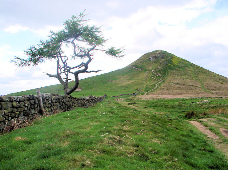
The simplest option is the direct there-and-back from the car park at Newton-under-Roseberry: a little over a mile in total, straight up the stepped path to the summit. It's steep and gets the heart going, but it's short, and families manage it regularly. Take your time on the steps and it's well within reach. The reward at the top is a 360-degree panorama: the Tees Valley and the coast one way, the Cleveland Hills and the moors the other.
The circular routes
For more of a walk, a circular of around five miles takes you up through Newton Wood, over the summit and out onto Newton Moor before looping back, quieter than the direct path once you're past the top. For a fuller day of about six miles, extend the loop east to Captain Cook's Monument on Easby Moor. Going clockwise gets the steepest climbing done earlier and gives the best views on the approach to the summit. Paths are well signed but can be very muddy after rain, and the descent from the summit is down steep stone steps.
Route map and wayfinding
Start: North York Moors National Park pay-and-display car park at Newton-under-Roseberry, A173 (postcode TS9 6QR, grid ref NZ 570 128)
Start coordinates: 54.5057, -1.1050
- Newton-under-Roseberry car parkPay-and-display on the A173; the path leaves from the top of the car park.
- Newton WoodClimb through the woodland below the hill before the open ground.
- The summitA steep stepped pull to the trig point and the 360-degree panorama.
- Newton MoorOn the circular, continue over the top and out onto open moorland.
- Captain Cook's Monument (longer loop)Extend east to the 1827 obelisk on Easby Moor, then loop back.
Wayfinding points are a guide only, check waymarking on the ground.
Captain Cook's Monument
The tall obelisk on Easby Moor was raised in 1827 in memory of Captain James Cook, who spent his boyhood in nearby Great Ayton. He went to school there and is said to have climbed Roseberry Topping as a boy, his first taste of the horizon. The monument makes a natural turning point on the longer circular, with fine views of its own back to the Topping.
Parking, getting there and facilities
The usual start is the North York Moors National Park pay-and-display car park at Newton-under-Roseberry, on the A173 between Guisborough and Great Ayton (postcode TS9 6QR). Note the charge applies to National Trust members too, and it's busy on fine weekends, so arrive early. Check the current charge on the National Park website. There's no café or shop on the walk itself, so bring water and a snack; refreshments are in Great Ayton and Newton. By bus, services run to Newton-under-Roseberry from the surrounding towns.
When to go
Roseberry Topping is glorious on a clear day and understandably popular, expect company at the summit on sunny weekends. It's exposed up top, so take layers whatever the season, and wear proper boots: the paths get muddy and the summit steps can be slippery when wet. A weekday or an early start rewards you with the views and fewer people. Our plan your visit guide covers the practicalities of a day out here.
Walking with dogs
Dogs are welcome but should be kept under control and on a lead around the livestock that graze the moor and woodland. See our walking with dogs guide for the moorland rules and seasonal hazards.
Make a day of it
Roseberry Topping sits in the north-western corner of the park, a different side from the Pickering-and-Dalby end, good walking country in its own right, close to Great Ayton, the Cleveland Hills and the Cleveland Way. If you're collecting the park's great natural landmarks, pair it in spirit with the Hole of Horcum at the southern end, or browse more walks in the North York Moors.
Where to stay
For a base on this side of the moors, see where to stay in the North York Moors.
Roseberry Topping walk FAQs
- How long is the Roseberry Topping walk?
- The direct climb is just over a mile there and back and takes under an hour; circular routes run from about 5 miles to around 6 miles including Captain Cook's Monument.
- How hard is it?
- Moderate: a short but steep climb with steps, and a steep stepped descent; nothing technical.
- Where do you park?
- The North York Moors National Park pay-and-display car park at Newton-under-Roseberry on the A173, postcode TS9 6QR (charge applies, including for National Trust members).
- How high is Roseberry Topping?
- 320 m (1,049 ft).
- Can you take dogs?
- Yes, on a lead around livestock.
Stay near the hill
Great Ayton and the villages under the northern escarpment put the Newton-under-Roseberry car park within a few minutes' drive, handy for an early start before it fills.
Browse places to stay