Walks
Whitby to Robin Hood's Bay
By Jon Cosson · Updated 2 November 2026 · Checked
Park boundary status unconfirmedThe big coastal walk out of Whitby: Around 7 miles one way, south on the Cleveland Way from the abbey headland along a fine stretch of cliff, finishing down the steep street of Bay Town. Come back by bus, or walk the level Cinder Track home.
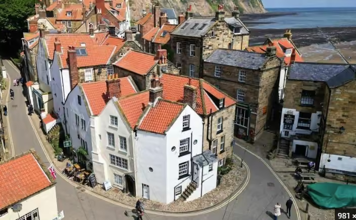
Bay Town at the end of the cliff path, the reward for the coastal stage.
The walk at a glance
- Distance
- 7 miles / 11.3 km, linearVisit North Yorkshire gives around 7 miles from Whitby Abbey. The former National Trails 6.4-mile page is unavailable; starts and variants differ.
- Ascent
- No published ascent figure. National Trails publishes distances for the Cleveland Way but no ascent figures for its sections, and its nearest published section is Sandsend to Robin Hood's Bay at 10 miles (16.3 km)
- Time
- Around 3 to 4 hours, Visit North Yorkshire.
- Difficulty
- A fine stretch of cliff on the way south, with steep sections above the sea; the Cinder Track return is level, shaded and easy underfoot
- Start & parking
- Abbey Headland car park, Whitby; The abbey headland, Whitby; 9am to 6pm: 2 hours £4.90, 4 hours £8.10, 6 hours £10.20, 24 hours £13.10; 358 spaces
- Waymarking
- Follows the Cleveland Way south from the abbey headland
- Dogs
- Keep them on a lead near livestock and on the steep sections above the sea. The Cinder Track return is shaded and easy underfoot.
- Toilets
- At the Marina car park, including Changing Places, RADAR key
- Public transport
- Arriva X93/X94 is named by the visitor authority for Bay to Whitby. Select the actual dated journey and upper-village stop before walking; no winter frequency assumed.
- Hazards
- Keep dogs on leads beside the sheer drops and livestock. Children need close supervision at unfenced edges. No full-route wheelchair or buggy suitability confirmed; the lower-village bank is steep. Check local signs for livestock, ground-nesting birds and forest work. Wet paths, mud and bracken can obscure footing; do not push through vegetation to make a shortcut.
Opens the walk finder with this walk’s length and effort already set.
About this route
Route guidance from the published sources below, with mapping where available. Information last checked: 1 November 2026. Unconfirmed details and separately dated variants remain explicit. If you find a change, use the contact page.
- October 2026: https://www.nationaltrail.co.uk/en_GB/trails/cleveland-way/circular-linear-walks/whitby-to-robin-hoods-bay/
- Visit North Yorkshire
- National Trails
- https://www.northyorks.gov.uk/roads-parking-and-travel/car-park-directory/car-park-directory/marina-back-car-park-whitby
- https://www.northyorks.gov.uk/roads-parking-and-travel/car-park-directory/car-park-directory/bank-top-car-park-robin-hoods-bay
- https://visitnorthyorkshire.com/index/whitby-to-robin-hoods-bay-walk
- https://www.northyorkmoors.org.uk/plan-your-visit/car-parks-and-toilets/car-park-list
Distance notes: Visit North Yorkshire gives around 7 miles from Whitby Abbey. The former National Trails 6.4-mile page is unavailable; starts and variants differ..
Ascent: No published ascent figure. National Trails publishes distances for the Cleveland Way but no ascent figures for its sections, and its nearest published section is Sandsend to Robin Hood's Bay at 10 miles (16.3 km).
Area map
Whitby area; the route starts on the abbey headland. This map shows the area, not a verified route line.
Current route and access check
Park boundary status unconfirmedFrom Whitby Abbey follow Cleveland Way signs south along the clifftops towards Robin Hood's Bay. Do not include a descent to Saltwick Bay as an unconditional part of this route. The Cinder Track return adds another walk; a bus return starts in upper Bay.
Keep dogs on leads beside the sheer drops and livestock. Children need close supervision at unfenced edges. No full-route wheelchair or buggy suitability confirmed; the lower-village bank is steep.
Route file and official map
No licence permitting this guide to redistribute the GPX was established. Use the official route platform directly.
Official route or reserve guidance
Details not confirmed
- No official ascent or walk-start OS grid reference found.
- Exact Abbey Headland parking postcode and current price not independently rechecked; consult its council page.
The route in outline
This is a cliff-path route; if adding a beach detour, check the Whitby tide guidance and coastal cut-off warnings first.
From the abbey headland above Whitby, head south on the Cleveland Way. Visit North Yorkshire gives around 7 miles from Whitby Abbey and 3 to 4 hours. The old National Trails stage URL is no longer available. Follow Cleveland Way waymarks along the cliff and descend into Bay Town at the end. Carry the OS sheet and start early enough that the light is not against you.
Getting back
It is a one-way walk, so plan the return before setting off. Arriva X93/X94 serves the upper village at Thorpe Lane, returning towards Whitby. Check the stop display for the correct direction and last service. The Cinder Track offers a separate inland return; no checked distance for that alternative is given here.
Refreshments in Robin Hood's Bay
- The Bay Hotel. Wainwright's Bar is seasonal.
- Hotel Victoria. Dogs in the Captain's Quarters rooms only, not the main hotel.
- The Grosvenor Hotel.
Walking it with a dog
Keep dogs on a lead near livestock and on the steep sections above the sea. The Cinder Track return is the gentler half by some distance: shaded and easy underfoot. More in our dog-friendly guide.
A shorter alternative
For another nearby walk, see Boggle Hole.
The one-way coastal stage is a proper day. If that is more than you want, the walk west to Sandsend is about 6 miles there and back and not flat on the cliff alternative.
Whitby to Robin Hood's Bay walk FAQs
How far is Whitby to Robin Hood's Bay on foot?
Around 7 miles one way, south on the Cleveland Way from the abbey headland along a fine stretch of cliff, finishing in Bay Town.
How do you get back from Robin Hood's Bay?
Arriva X93/X94 serves Robin Hood's Bay and Whitby. The published stop is Thorpe Lane in the upper village. Check the current direction and timetable at the stop; a shore-level pickup is not offered. The Cinder Track is another return option, but its full return distance was not confirmed.
Is the walk suitable for dogs?
Yes, with a lead near livestock and on the steep sections above the sea. The Cinder Track return is shaded and easy underfoot.
Can you cycle the Cinder Track instead?
The Cinder Track is covered in the cycling guide. Check current surface and access conditions before using it as the return leg.
Stay on the coast
Whitby at one end, Robin Hood's Bay at the other, and the walk works from either.
Browse places to stay