Walks
The Cleveland Way
By Jon Cosson · Updated 18 October 2026
The Cleveland Way is a National Trail of 109 miles (175 km) from Helmsley to Filey Brigg, as published by National Trails. Its horseshoe route follows the North York Moors escarpment and Cleveland Hills before turning south along the coast. This guide covers the route, stages and where to start.
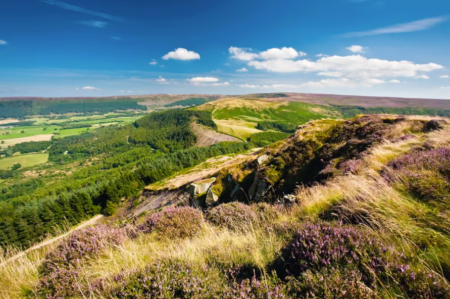
The moorland half of the Cleveland Way follows high edges above the wooded dales.
The walk at a glance
- Distance
- 109 miles / 175.4 km, linearNine stages from Helmsley to Filey Brigg
- Ascent
- No total ascent figure is published by National Trails, which offers a route-by-route calculator instead. The Cleveland Hills and the cliff-top miles add far more climbing than the mileage suggests
- Time
- Most walkers take nine days, at around twelve miles a day
- Difficulty
- Moderate to strenuous, no scrambling, but the Cleveland Hills roll steeply and the cliff-top miles add more ascent than people expect
- Start & parking
- Cleveland Way car park, Helmsley (North Yorkshire Council, long stay); Helmsley market square; 9am to 6.30pm daily: 1 hour £2.50, 2 hours £3.70, 3 hours £4.40, 6 hours £7.30, 24 hours £8.70; nearest postcode YO62 5AT
- Waymarking
- Well waymarked with the National Trail acorn
- Dogs
- Keep dogs on leads across moorland.
- Pushchairs
- Not suitable as a through route. National Trails describes the path as challenging in places, especially the coastal sections
- Wheelchairs
- Not suitable as a through route: moorland and unfenced cliff-top paths for most of its length
- Toilets
- At the Cleveland Way car park, accessible with a RADAR key
- Public transport
- EY 28 between Scarborough and Helmsley, and the seasonal Moorsbus. National Trails say buses reach Helmsley from York, Malton and Scarborough. Check times before you travel.
- Best season
- May and June give long days and dry going
- Hazards
- Exposed moor, patchy mobile signal and cliff edges on the coastal half
Opens the walk finder with this walk’s length and effort already set.
About this route
Route compiled from Ordnance Survey mapping and the published sources below. Parking, grid reference and transport details checked on 18 October 2026. If you walk it and find a change, use the contact page.
- National Trails
- https://www.nationaltrail.co.uk/en_GB/trails/cleveland-way/
- https://www.northyorks.gov.uk/roads-parking-and-travel/car-park-directory/car-park-directory/cleveland-way-car-park-helmsley
Distance notes: Nine stages from Helmsley to Filey Brigg.
Ascent: No total ascent figure is published by National Trails, which offers a route-by-route calculator instead. The Cleveland Hills and the cliff-top miles add far more climbing than the mileage suggests.
Area map
Helmsley start area. This map shows the area, not a verified route line.
Length and endpoints checked 18 October 2026 against National Trails.
The route in one paragraph
The Cleveland Way starts in the market square at Helmsley and runs west and north along the moorland escarpment, past Sutton Bank, the White Horse and Osmotherley, then east over the switchback of the Cleveland Hills and around Urra Moor, the highest ground in the national park. It reaches the sea at Saltburn and turns south for the whole North Yorkshire coast: Staithes, Runswick Bay, Sandsend, Whitby, Robin Hood's Bay, Ravenscar and Scarborough, finishing on Filey Brigg.
It was opened on 24 May 1969 as the second National Trail in England and Wales, and it is waymarked throughout with the National Trail acorn. Roughly half is moorland and half is coast, which is what makes it unusual among long-distance paths: two entirely different walks joined end to end.
Stage by stage
A conventional nine-day itinerary looks like this. Distances are approximate and the daily ascent, not the mileage, sets the pace.
| Stage | Distance | What you get |
|---|---|---|
| Helmsley to Sutton Bank | 10 miles | Rievaulx Abbey just off route, then the climb to the escarpment. |
| Sutton Bank to Osmotherley | 12 miles | The White Horse, Gormire Lake below, and the long edge north. |
| Osmotherley to Clay Bank | 11 miles | The switchback of the Cleveland Hills. The hardest day. |
| Clay Bank to Kildale | 9 miles | Round Urra Moor, the highest ground in the park. |
| Kildale to Saltburn | 12 miles | Captain Cook's Monument, Roseberry Topping, then the sea. |
| Saltburn to Staithes | 10 miles | Boulby, the highest cliffs on England's east coast. |
| Staithes to Whitby | 11 miles | Runswick Bay, Kettleness, Sandsend sands and the abbey. |
| Whitby to Scarborough | 21 miles | Usually split at Robin Hood's Bay or Ravenscar. |
| Scarborough to Filey Brigg | 13 miles | Cayton Bay, Filey Brigg and the finish stone. |
The five best day walks
You do not have to walk the whole thing. These sections stand alone and each makes a good day out with a car or a bus at both ends.
Sutton Bank and the White Horse. The escarpment edge with the whole Vale of York below and Gormire Lake in the trees, famously called the finest view in England by James Herriot, who lived nearby. See our Sutton Bank guide.
Roseberry Topping from Great Ayton. The park's most recognisable hill, with Captain Cook's Monument on Easby Moor next door, a natural pairing from Great Ayton. Route details in our Roseberry Topping walk.
The Wainstones. Weathered sandstone tors on Cold Moor between Clay Bank and Carlton Bank, on the toughest and best of the moorland stages.
Whitby to Robin Hood's Bay. Seven cliff-top miles from the abbey to Bay Town, with the bus or the level Cinder Track for the return.
Ravenscar to Robin Hood's Bay. Cliffs out, old railway back, seals and alum works on the way. The finest circular on this coast.
When to go, and what to expect
May and June give long days, dry going and ground-nesting birds on the moor. Late August into early September brings the heather into full purple, the best photography of the year, and the busiest beds. Autumn is quiet and clear; winter is short-day walking on exposed ground with real weather. See when to visit.
Practical notes that matter more here than the mileage: the moorland half has few shops and patchy mobile signal, so carry water and food for the day. Keep dogs on leads across moorland between March and July and near livestock at any time, see our dogs and access page. Cliff edges on the coastal half are unfenced and undercut, and the path is diverted from time to time by slips; follow the signed diversions rather than the map.
Cleveland Way FAQs
- How long is the Cleveland Way?
- 109 miles (175 km) from Helmsley to Filey Brigg. It was officially opened on 24 May 1969 and was the second National Trail in England and Wales, running in a horseshoe: west along the moorland escarpment, north over the Cleveland Hills, then south down the whole North Yorkshire coast.
- How many days does the Cleveland Way take?
- Most walkers take nine days, at an average of around twelve miles a day. Strong walkers do it in six or seven; taking eleven or twelve gives you time for Whitby, Robin Hood's Bay and the abbeys. There is a lot of ascent on the moorland half, treat the mileage as a minimum, not a measure.
- Which direction should you walk the Cleveland Way?
- Helmsley to Filey is the standard direction. It puts the hardest climbing early while you are fresh, saves the coast for the second half as a reward, and generally keeps the prevailing south-westerly wind behind you. It also means you finish at the sea, which matters more than it sounds.
- Is the Cleveland Way hard?
- It is moderate to strenuous rather than technical. There is no scrambling and the route is well waymarked with the National Trail acorn, but the Cleveland Hills section rolls steeply up and down, the moor is exposed to weather, and the cliff-top miles add more ascent than people expect.
- What are the best day walks on the Cleveland Way?
- Sutton Bank to the White Horse for the escarpment view, Roseberry Topping and Captain Cook's Monument from Great Ayton, the Wainstones over Cold Moor, Whitby to Robin Hood's Bay along the cliffs, and Ravenscar to Bay Town returning on the Cinder Track.
- Can you camp on the Cleveland Way?
- Not wild, there is no right to wild camp in the North York Moors and the moorland is working land with nesting birds and a real wildfire risk. Use the campsites, bunkhouses, hostels, pubs and B&Bs along the route, and book ahead in summer; the coastal half fills early.
Beds along the trail
Helmsley, Osmotherley, Great Ayton, Saltburn, Staithes, Whitby, Robin Hood's Bay and Scarborough all sit on or beside the route. Book the coastal half early, it fills months ahead in summer.
Browse places to stay