Walks
The Mallyan Spout walk
Tucked into a wooded gorge below the village of Goathland, Mallyan Spout is the tallest waterfall in the North York Moors. A 70-foot ribbon of water spilling over a mossy cliff into the beck below. A short but characterful walk from the village brings you to it, and a loop back over the fields makes a satisfying morning.
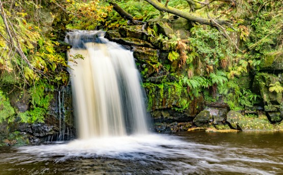
The falls in full flow after rain, framed by mossy rock and ferns in the wooded gorge below Goathland.
The waterfall
Mallyan Spout is not a broad, thundering fall. It is a tall, slender one, water dropping some seventy feet over a mossy, fern-hung ledge into West Beck. That makes it entirely weather-dependent: after heavy rain it is genuinely spectacular, and in a dry summer it can be little more than a shining stain on the rock. Check the Moors weather before you plan a trip specifically for the falls.
The route
From Goathland, the signed path beside the Mallyan Spout Hotel drops steeply into the gorge to meet West Beck. Turn left along the beck and follow it upstream; the final approach is rocky and uneven, with boulders to step over and water underfoot, and the falls appear on your right beneath an overhanging cliff. Most walkers return the same way, but the classic circular continues along the beck and climbs back to the village by field paths and lanes, making a loop of around three miles.
Route map and wayfinding
Start: Goathland village, at the western end near the Mallyan Spout Hotel
Start coordinates: 54.3988, -0.7215
- Goathland villagePark in the village and walk to the western end, past the Mallyan Spout Hotel.
- Descent into the gorgeA steep, stepped path drops through woodland to the bank of West Beck.
- Beckside scrambleTurn upstream and pick your way over wet rock and boulders for a few hundred yards.
- Mallyan SpoutThe falls drop from the cliff on your right, the turning point of the walk.
- Loop back to the villageEither retrace your steps, or continue along the beck and climb back by field paths.
A downloadable GPX track for this route is still to be added, for now, follow the wayfinding points above alongside OS Explorer OL27.
Path conditions in the gorge change after rockfall and flooding, confirm the route is open on the day.
Parking and getting there
Goathland has village parking that fills quickly on summer weekends and through the school holidays; arriving before mid-morning makes life much easier. Better still, arrive by train: Goathland is a stop on the North Yorkshire Moors Railway, and the station is a short walk from the village centre.
When to go and what to wear
Autumn and winter, after prolonged rain, give the fullest flow; spring adds wild garlic and birdsong in the gorge. Whatever the season, wear boots with grip. The rock beside the beck is wet, mossy and genuinely slippery, and trainers are not enough. This is not a buggy-friendly or step-free route.
Walking with dogs
Dogs are welcome on a lead. The boulder section close to the falls is awkward for small or older dogs, and the sheep-grazed fields on the return loop mean leads throughout. See our North York Moors with dogs guide for more.
While you're in Goathland
Goathland is a destination in its own right, the "Aidensfield" of Heartbeat, and its railway station stood in for Hogsmeade in the Harry Potter films. Keen walkers can extend the day on the Goathland waterfalls walk, which strings together several falls including Thomason Foss; see also our waterfalls guide. Looking for a base? See where to stay.
Mallyan Spout walk FAQs
- How long is the Mallyan Spout walk?
- The usual circular from Goathland is around three miles and takes an hour and a half to two hours. You can shorten it to an out-and-back to the falls and return the same way.
- How hard is the walk to Mallyan Spout?
- Moderate. The descent into the gorge is straightforward, but the last stretch beside the beck is rocky, uneven and often wet, and you may need to pick your way over boulders.
- Where do you park for Mallyan Spout?
- In Goathland village. The signed path to the falls starts beside the Mallyan Spout Hotel at the western end of the village; parking is limited on busy days, so arrive early.
- How tall is Mallyan Spout?
- Around 70 feet, which makes it the tallest waterfall in the North York Moors. It is at its most dramatic after heavy rain and can thin to a trickle in a dry spell.
- Can you take dogs to Mallyan Spout?
- Yes, on a lead. The rocky, slippery section close to the falls is hard work for small or elderly dogs, so judge it on the day.